 |
P-wave tomography and origin of the Changbai intraplate volcano in Northeast Asia |
Jianshe Lei
Seismological Laboratory,
Institute of Crustal Dynamics, China Earthquake Administration,
Xisanqi, Haidian District, Beijing 100085, China, jshlei_cj@hotmail.com
This webpage is a synopsis of the paper:
Lei. Jianshe & D.
Zhao, P-wave tomography and origin of the Changbai
intraplate volcano in Northeast Asia, Tectonophysics, 397,
281– 295, 2005.
Changbai volcano, also called Tianchi
or Baitoushan volcano, is located in the Changbai Mountains,
close to the boundary between NE China and North Korea
(Figure 1a). Changbai volcano erupted in BC 1120, AD
1050, 1413, 1597, 1668, and 1702 (Simkin & Siebert,
1994; Liu, 2000). However, the origin of such
intraplate volcanoes is still unclear. Some researchers
suggested that Changbai volcano originated either from
accretion processes at the craton margin since the
Mesoproterozoic or as a result of subduction processes
associated with the Pacific plate before the opening
of the Japan Sea (e.g., Zhang & O’Reilly,
1997). Turcotte & Schubert (1982) assumed
that it is a hotspot like Hawaii, while Tatsumi
et al. (1990) considered it to be a kind of back-arc
volcano. Global tomographic models are still too poorly
resolved to show the detailed structure and reveal
the origin of the Changbai intraplate volcano.
Many
researchers have used geological, geochemical and geophysical
approaches to study Changbai volcano (e.g., Zhang & Tang,
1983; Zindler & Hart,
1986; Zhao, 1991; Basu et al., 1991; Zhang & O’Reilly,
1997; Fan et al., 1999a, b; Tang et al.,
1999; Wang et al., 2003). Magnetotelluric
soundings show that low-resistivity anomalies exist
beneath it in the crust (Tang et al., 1997,
2001). Seismic explosion experiments revealed low-velocity
anomalies in the crust and upper mantle down to a depth
of 40 km, suggesting the existence of magma chambers
(Zhang et al., 2002).
With the recent installation
of 19 portable seismic stations during seismic experiments
in NE China (Wu & Hetland,
1999), a few studies investigated the structure
under NE China. For example, receiver function techniques
were applied to the data set recorded by the portable
seismic network to study crustal structure and upper
mantle discontinuities (Ai et al., 2003; Li & Yuan,
2003; Hetland et al., 2004). These studies
showed that the crust is thicker and contains low-velocity
anomalies beneath Changbai volcano, and that the subducted
Pacific slab lies flat in the mantle transition zone
there. It has also been suggested that pieces of slab
material penetrated into the lower mantle under NE
Asia (Ai et al., 2003). However, no tomographic
study of this was made using the new data set.
The availability of abundant teleseismic data recorded
by the portable seismic network enabled us to determine
the 3-D velocity structure beneath Changbai volcano
and investigate the origin of the volcano.
Figure 1a shows the distribution
of seismic stations used in this study. The portable
seismic network contains 19 broad-band seismic stations
equipped with Guralp 3T three-component digital seismometers
(Wu & Hetland,
1999; Hetland et al., 2004). In this work,
data from 3 permanent seismic stations, MDJ, HIA, and
BJT were also used (Figure 1a). These stations
are sited adjacent to the portable seismic network
and have recorded data since 1986. The 19 temporary
seismic stations were located around Changbai volcano
and were in operation from late June to September 1998.
Ten continued recording until April 1999 (Hetland
et al., 2004). The geometry of the subducting
Pacific slab as estimated from the deep seismicity
by Gudmundsson & Sambridge (1998) is also
shown in Figure 1a.
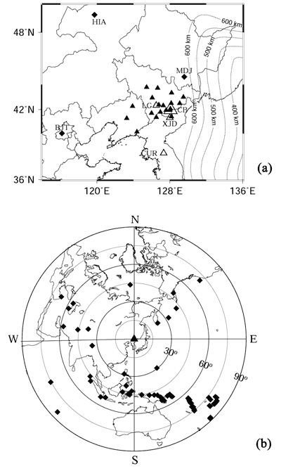
Figure 1: (a) Locations
of 19 portable seismic stations (solid triangles) and
3 permanent stations (diamonds) used in this study.
Open triangles denote intraplate volcanoes. CB, Changbai;
LG, Longgang; XJD, Xianjindao; CUR, Ch’Uga-Ryong
(Simkin & Siebert, 1994). The dotted lines
show the depth contours of the Wadati-Benioff deep
seismic zone (Gudmundsson & Sambridge,
1998). (b) Epicentral locations of the 68 teleseismic
events (diamonds) used in this study. The triangle
denotes the center of the NE China Seismic Network.
P-wave arrival times were
hand-picked from high-quality original seismograms.
The resulting data set contains 548 high-quality P arrival
times from 68 teleseismic events (M > 4.8; Figure
1b). The events selected have a good azimuthal coverage
except in the Pacific Ocean and Russia. Except for
one event in Kamchatka that has an epicentral distance
of about 25°, all events lie in the range 30-90° from
the network.
The tomographic method of Zhao
et al. (1994)
was used to determine the 3-D P-wave velocity
(Vp) structure beneath Changbai volcano. Our
results (Figure 2) show a columnar low-velocity anomaly
extending to 400 km depth with a P-wave velocity
reduction of up to 3%. High-velocity anomalies are
visible in the mantle transition zone, and deep-focus
earthquakes occur at depths of 500-600 km beneath the
region, suggesting that the subducting Pacific slab
lies flat in the transition zone there, as imaged clearly
by global tomography (Zhao, 2004; Lei & Zhao,
2006a). Such structural features are similar to those
beneath Tengchong volcano in SW China (e.g., Lei
et al., 2009a), but different from those under
the Hainan, Hawaii and Iceland hotspots (e.g., Zhao,
2001a; Montelli
et al.,
2004; Lei & Zhao,
2006b; Lei
et al.,
2009b).
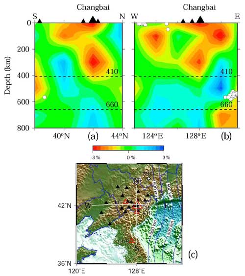
Figure 2: (a)
North-south, and (b) east-west vertical cross
sections of P-wave velocity images. Red and
blue colors denote low and high velocity anomalies,
respectively. The velocity perturbation scale is shown
below the cross sections. Black triangles in (a) and
(b) denote volcanoes. White dots show earthquakes within
100 km of the profiles. The two dashed lines denote
the 410- and 660-km discontinuities. The locations
of the cross sections are shown in the insert map (c).
Labels in (c) are the same as in Figure 1a.
These results indicate
that the active intraplate volcanoes in NE Asia are
not hotspots but a kind of back-arc volcano closely
related to the subduction process of the Pacific slab.
Low-velocity anomalies in back-arc regions are generally
associated with back-arc magmatism and volcanism caused
by the deep dehydration process of the subducting slab
and convective circulation process of the mantle wedge
(Zhao et al., 1997; Zhao,
2001b). These processes may lead to large-scale upwelling
of asthenosphere under NE Asia and cause intraplate
volcanism and continental rift systems in the region. Tatsumi
et al. (1990) first invoked asthenospheric injection
to explain the formation of Wudalianchi and Changbai
volcanoes, but they did not consider the flat Pacific
slab under the region because such a slab structure
was unknown at that time. Here we modified the model
of Tatsumi et al. (1990) to emphasize the
role of the flat Pacific slab in the formation of intraplate
volcanism in E Asia (Figure 3).
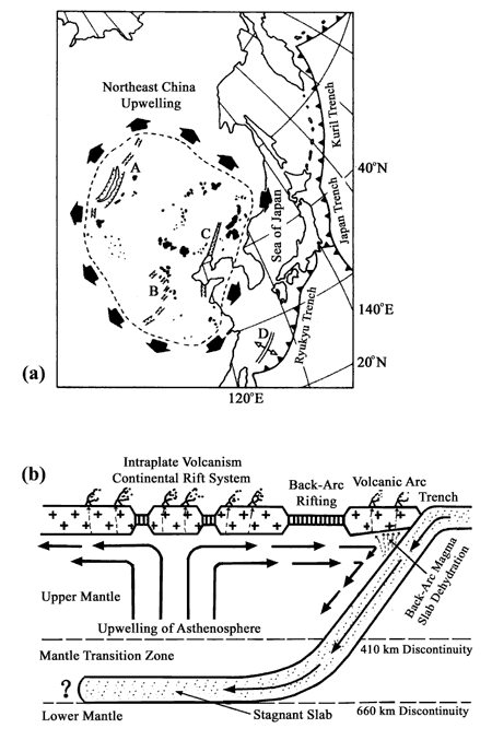
Figure 3: (a) Tectonic
features on the surface in the NW Pacific and NE Asia.
Black patches denote Cenozoic basalts. A, Baikal rift;
B, Shanxi graben; C, Tancheng-Lujiang fault zone; D,
Okinawa trough. (b) Schematic east-west vertical section
showing upper mantle structure beneath NE Asia. The
subducting Pacific slab becomes flat in the mantle
transition zone. The deep dehydration process of the
slab and convective circulation process in the mantle
wedge cause upwellings of high-temperature asthenospheric
materials, leading to the formation of the continental
rift system as well as intraplate volcanoes in NE Asia
(modified from Tatsumi et al., 1990).
References
-
Ai, Y., Zheng, T., Xu, W.,
He, Y., Dong, D., 2003. A complex 660 km discontinuity
beneath northeast China. Earth Planet. Sci. Lett. 212,
63-71.
-
Basu, A., Wang, J., Huang, W., 1991.
Major element, REE, and Pb, Nd and Sr isotropic geochemistry
of Cenozoic volcanic rocks of eastern China: implications
for their origin from suboceanic-type mantle reservoirs. Earth
Planet. Sci. Lett. 105, 149-169.
-
Fan, Q., Liu, R., Li, D., Li,
Q., 1999a. Significance of K-Ar age of bimodal
volcanic rocks at Wangtian’s
Volcano, Changbaishan area. Chinese Sci. Bull. 44,
660-663.
-
Fan, Q., Liu, R., Wei, H., Sui, J., Li,
N., 1999b. Petrogeochemical characteristics of Holocene
eruption of the Tianchi Volcano, Changbai Mountains. Geolog.
Rev. 45 (Suppl.), 263-271.
-
Gudmundsson,
O., Sambridge, M., 1998. A regionalized upper mantle
(RUM) seismic model. J. Geophys. Res. 103,
7121-7136.
-
Hetland, E., Wu, F., Song, J., 2004.
Crustal structure in the Changbaishan volcanic area,
China, determined by modeling receiver functions. Tectonophysics 386,
157-175.
-
Lei, J., Zhao, D., 2006a. Global P-wave
tomography: On the effect of various mantle and core
phases. Phys.
Earth Planet. Inter. 154,
44-69.
-
-
Lei, J., Zhao, D., Su, Y., 2009a. Insight
into the origin of the Tengchong intraplate volcano
and seismotectonics in southwest China from local
and teleseismic data. J.
Geophys. Res., in press.
-
Lei, J., Zhao, D., Steinberger,
B., Wu, B., Shen, F., Li, Z., 2009b. New seismic
constraints on the upper mantle structure of the
Hainan plume. Phys.
Earth Planet. Inter., 173,
33-50.
-
Li,
X., Yuan, X., 2003. Receiver functions in northeast
China—implications for slab penetration into
the lower mantle in northwest Pacific subduction
zone. Earth
Planet. Sci. Lett. 216, 679-691.
-
Liu, R., 2000. Active volcanoes
in China. Seismological Press, Beijing, pp. 11-44.
-
Montelli, R., Nolet, G., Dahlen,
F., Masters, G., Engdahl, R., Hung, S., 2004, Finite-frequency
tomography reveals a variety of plumes in the mantle, Science 303,
338-343.
-
Simkin, T., Siebert, L., 1994. Volcanoes
of the world. Geoscience Press, Washington D.C.,
p. 111.
-
Tang, J., Liu, T., Jiang, Z., 1997. Preliminary
observations of the Tianchi volcano area in Changbaishan
Mountain by MT method. Seismol. Geology 19,
164-170.
-
Tang, J., Jin, G., Zhao, G., 1999. Induction
arrow and its application in Tianchi Volcano, Changbai
Mountains. Geolog.
Rev. 45, 294-303.
-
Tang, J., Deng,
Q., Zhao, G., 2001. Electric conductivity and magma
chamber at the Tianchi volcano area in Changbaishan
Mountain. Seismol. Geology 23,
191-200.
-
Tatsumi, Y., Maruyama, S., Nohda, S.,
1990. Mechanism of backarc opening in the Japan Sea:
role of asthenospheric injection. Tectonophysics 181,
299-306.
-
Turcotte, D. L., Schubert G., 1982. Geodynamics,
applications of continuum physics to geological problems.
John Wiley and Sons press, New York, p. 44.
-
Wang, Y.,
Li, C., Wei, H., Shan, X., 2003. Late Pliocene-recent
tectonic setting for the Tianchi volcanic zone, Changbai
Mountains, northeast China. J. Asia Earth Sci. 21,
1159-1170.
-
Wu, F., Hetland, E., 1999. The Changbaishan,
China, PASSCAL experiment, in: 21st Seismic Research
Symposium: Technologies
for Monitoring the Comprehensive Nuclear-Test-Ben Treaty,
Las Vegas, NV, USA.
-
Zhang, C., Zhang, X., Zhao, J.,
Liu, B., Zhang, J., Yang, Z., Hai, Y., Sun, G., 2002.
Crust-mantle structure of the Changbaishan Tianchi
volcanic region and its vicinity: An exploratory
study and inferences. Chinese J.
Geophys. 45, 862-871.
-
Zhang, L.,
Tang, X., 1983. Subduction of the West Pacific Plate
and deep-source seismic zone in Northeast China. Acta
Geophys. 26, 331-340.
-
Zhang, M.,
O’Reilly, S., 1997. Geochemical evolution
of basaltic rocks from the Changbai Mountains:
implications for the nature of lithospheric mantle
beneath the NE margin of the Sino-Korean craton.
In: Lee, Y. and Kim, J. (Eds), Tectonic evolution of eastern Asian continent,
Geol. Soc. Korea 50th anniv. Int’l Symp.,
pp. 170-175.
-
Zhao, D., 2001a. Seismic structure and
origin of hotspots and mantle plumes. Earth Planet.
Sci. Lett. 192,
251-265.
-
Zhao, D., 2001b. Seismological structure
of subduction zone and its implications for arc magmatism
and dynamics. Phys.
Earth Planet. Inter. 127,
197-214.
-
Zhao, D., 2004. Global tomographic images
of mantle plumes and subducting slabs: insight into
deep Earth dynamics. Phys. Earth Planet. Inter. 146,
3-34.
-
Zhao, D., Hasegawa, A., Kanamori, H.,
1994. Deep structure of Japan subduction zone as
derived from local, regional, and teleseismic events. J.
Geophys. Res. 99,
22313-22329.
-
Zhao, D., Xu, Y., Wiens, D., Dorman,
L., Hildebrand, J., Webb, S., 1997. Depth extent
of the Lau back-arc spreading center and its relation
to subduction processes. Science 278,
254-257.
-
Zhao, Z., 1991. Charateristics of intermediate
and deep earthquakes in and near Japan Sea. Northeastern
Seismol. Res. 4, 37-43.
-
Zindler,
A., Hart, S., 1986. Chemical geodynamics. Ann.
Rev. Earth Planet. Sci. 14,
463-471.
last updated 24th
March, 2009 |