|
The
Galápagos Islands are the Result of a Mantle
Plume |
|
|
| |
Introduction
The prevailing view is that the Galápagos
Islands are due to a plume currently beneath the easterly
moving Nazca Plate. The Galápagos plume is
thought to lie about 250 km south of the Galápagos
Spreading Center (GSC), beneath the western islands
of Fernandina and Isabela, and it is thought that
there has been extensive interaction between the two
tectonic entities. In the past, the GSC has
jumped south and migrated north, so the hotspot has
produced variable amounts of material on both plates
through time. The plume is thought to contribute
material to GSC lavas, and lavas from the Galápagos
hotspot contain an unusually large component of upper
mantle material.
|
1. The plume
model
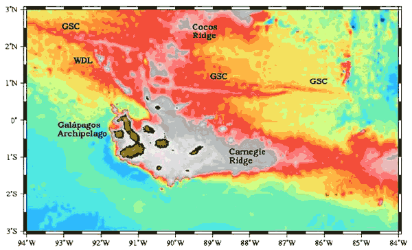
Figure 1: Map prepared by Bill Chadwick
of NOAA
The bathymetry of the Galapagos region
shows several tectonic provinces (Figure 1). From
south to north, some of the features are:
-
The
main Galapagos archipelago. The
hotspot is thought to lie underneath the volcanically-active
islands of Fernandina and Isabela (the equant, westernmost
island and the large, J-shaped island); the eastern
islands have much less volcanic activity.
-
The
Carnegie Ridge, which is thought
to be the hotspot trace on the Nazca plate.
The prominent saddle at 85.5°W is attributed
to the southern migration of the Galapagos Spreading
Center; the hotspot was under the Cocos plate at
the time the saddle was produced;
-
The
Wolf-Darwin Lineament (WDL) and
northern islands are thought to be produced by a
combination of high heat flow due to flow of plume
material toward the ridge and unusually strong deviatoric
stresses in the lithosphere owing to oblique spreading
across the 90.5° transform;
-
The
Galapagos Spreading Center (GSC),
the boundary between the Nazca plate to the south
and the Cocos plate to the north. It is an intermediate-spreading
ridge (about 58 km/my, roughly N-S spreading).
The bathymetric effects of the hotspot are clear;
and
-
The
Cocos Ridge, the trace of excess
crust produced by the hotspot, but on the Cocos
plate.
|
2. Isotopes indicate
a mantle plume
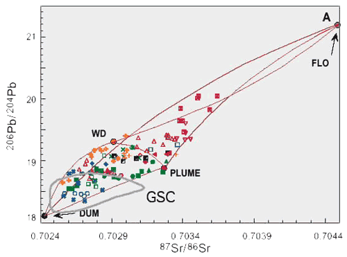
Figure 2
The istopic evidence has been interpreted
as mixing between a heterogeneous plume source (dominantly
PLUME, with domains of WD and FLO) and DUM. PLUME, WD,
FLO and DUM are compositional endmembers, as identified
by principal component analysis of isotopic and trace
element data on all Galapagos Island and seamount data
(Harpp & White, 2001). Note the substantial
overlap beteen island lavas and those from the GSC,
which has been interpreted as two-way mixing between
Galápagos plume material and depleted asthenosphere.
Figure 3
The isotopic characteristics of the
Galápagos Islands and seamounts show a regular
zonation (Figure 3, left panel). The DUM component is
concentrated in the center of the archipelago and increases
eastward. This has been attributed to torroidal
mixing between plume and upper mantle material, and
shearing of the plume by the Nazca plate (Figure 3,
right panel). The occurrence of FLO in the south and
WD in the north is attributed to zoning of heterogeneities
in the plume.
| |
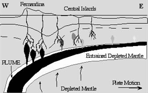
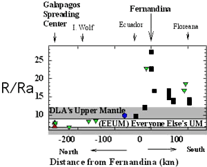
Helium isotope ratios show a different pattern:
the most "plume-like" signal is in the center
of the archipelago and in the FLO-bearing islands
to the south (Figure 4). The GSC, despite
being contaminated with plume Sr, Nd, and Pb,
lies within even the most conservative estimates
of MORB 3He/4He.
Figure 4
|
|
3. Age Progression Indicates
a Fixed-Source Hotspot
The Galápagos Islands
and seamounts along the Carnegie Ridges (Sinton
et al., 1996) show a progression of ages
(Figure 5). Many of the ages fall within
the estimate of Gripp & Gordon (1990)
of 37 km/Myr for the absolute motion of the Nazca
plate. More of the ages fit the fixed-source
hypothesis if 3 million years of activity on an
individual volcano is added. Field study
of some Galápagos volcanoes indicate that
such long durations of volcanism do take place.
The ages suggest that velocity of the Nazca plate
may have decreased at about 9 Ma. |
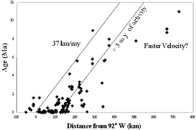
Figure 5 |
|
4. Subsidence patterns
indicate history of ridge migration over a fixed plume
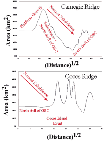
Figure 6
|
These plots show the cross
sectional areas of the two hotspot traces against
the square root of distance from the leading edge
of the hotspot. The decrease in elevation
of the Carnegie Ridge is much faster than predicted
by conductive cooling models ("Normal Subsidence").
For lithosphere out to about 625 km (17 Ma), this
is attributed to the northward drift of the GSC
away from hotspot, so progressively more crust
is produced on the Nazca plate and less on the
Cocos plate.
In contrast, the Cocos ridge
shows no regular subsidence. This is because
the GSC has been drifting north, and the hotspot
has had a progressively smaller effect on the
Cocos plate (i.e. the initial elevation of the
Cocos ridge has decreased for the past 17 million
years). The "Cocos Island Event" is thought
to have resulted from excess magmatism from an
abandoned rift produced by the southward stepping
of the GSC (Harpp et al., 2003). |
|
5. Transition-zone
thinning and seismic tomography show a mantle plume
S-wave arrival time tomography
indicates a steeply-dipping, sharply-bounded slow zone
(anomalies of about -2% relative to PREM) extending
to at least 400 km depth, beneath Fernandina and Isabela
islands in the western archipelago (Toomey et al.,
2001). Because the aperature of the array is only about
400 km, larger depths cannot be imaged.
The transition zone is 18 ±
8 km thinner just to the west of the archipelago than
the regional average (which is not significantly different
from PREM) (Hooft et al., 2003). This corresponds
to a temperature anomaly of +130 ± 60 K, and
could be explained by a plume that pierces the bottom
and top of the transition zone. The thin transition
zone coincides precisely with the low-velocity zone
in the upper mantle indicated by the tomography. |
| ... and
for the alternative view ... |
| References
-
Sinton, C.W., Christie, D.M. & Duncan, R.A., (1996), Geochronology
of Galapagos seamounts, J. Geophys. Res.,
101, 13,689-13,700.
-
Gripp, A.E. & Gordon, R.G., (1990), Current plate velocities
relative to the hotspots incorporating the NUVEL-1
global plate motion model, Geophys. Res. Lett.,
17, 1109-1112.
- Harpp, K. S., White, W. M. (2001). Tracing a mantle plume;
isotopic and trace element variations of Galápagos
seamounts. Geochemistry, Geophysics, Geosystems,
2,
46. DOI 2000GC000137.
-
Harpp, K. S.; Fornari, D. J.; Geist, D. J.; Kurz, M. D., Genovesa
Submarine Ridge: A manifestation of plume-ridge
interaction in the northern Galápagos Islands,
(2003), Geochemistry, Geophysics, Geosystems, 4, DOI
10.1029/2003GC000531.
- Hooft, E.E. & Toomey, D.R., Anomalously thin transition
zone beneath the Galápagos Hotspot, Earth
Planet. Sci. Lett., in press.
-
Toomey, D.R., Hooft, E.E., Solomon, S.C., James, D.E., and
Hall, M.L., (2001), Upper mantle structure beneath
the Galápagos archipelago from body wave
data, Eos Trans. AGU, 82
|
|
|