Summary
The Hawaii-Emperor island
and seamount chain is the product of a long-lived
volcanic center that has moved in various directions
relative to the Pacific plate. The volcanic center
is usually referred to as a "hotspot" and
the seamount-island chain as a "hotspot track".
Age data on the Hawaii-Emperor chain indicates a remarkably
linear trend of age vs. distance from Hawaii along
the chain. Age progression continues to the oldest
seamount at the northern end of the Emperor Chain,
Meiji, 85 m.y. old. This seamount is close to the
Aleutian trench. An unanswered question is whether
the Emperor Chain once continued to the north, with
seamounts older than Meiji that have been subducted
into the trench. A corollary to this question is the
ultimate age of the hotspot – when did it initiate?
In this note I suggest that Meiji is in fact the oldest
seamount in the chain and that the hotspot initiated
as a result of significant reorganizations on the
spreading boundaries of the Pacific plate, i.e., as
a result of tectonic processes. It is probable that
other topographic features in the North Pacific such
as the Shatsky and Hess Rises were also generated
by tectonic processes. I propose that hotspots like
Hawaii are initially formed by tectonic (i.e., shallow)
processes, although the mechanisms for their longevity
remain unknown.
This posting is a summary
of a paper submitted to the proceedings of the AGU
Chapman Conference “The Great Plume Debate:
The Origin and Impact of LIPs and Hot Spots”
Tectonic
Evolution of the North Pacific
To examine initiation of the Hawaii
hotspot we need to understand the tectonic evolution
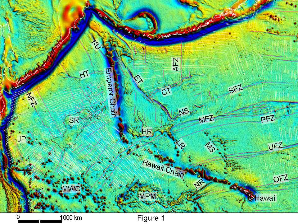
of the North Pacific. Tectonic information from the
area comes from the mapping of oceanic spreading anomalies,
fracture zones and other topographic features (Figures
1 and 2). Topographic features (except Shatsky Rise)
show up clearly on the satellite gravity data (Sandwell,
2005) used in these figures. The most prominent
feature is the Hawaii-Emperor chain, but for now we
will concentrate on other tectonic information. Figure
1 is a view of the satellite gravity. Image processing
used to produce the figure, with artificial illumination
from the northeast, is designed to enhance subtle
features in the data; fracture zones are especially
clear. Magnetic lineations, interpreted fracture zones
and other topographic features are included in Figure
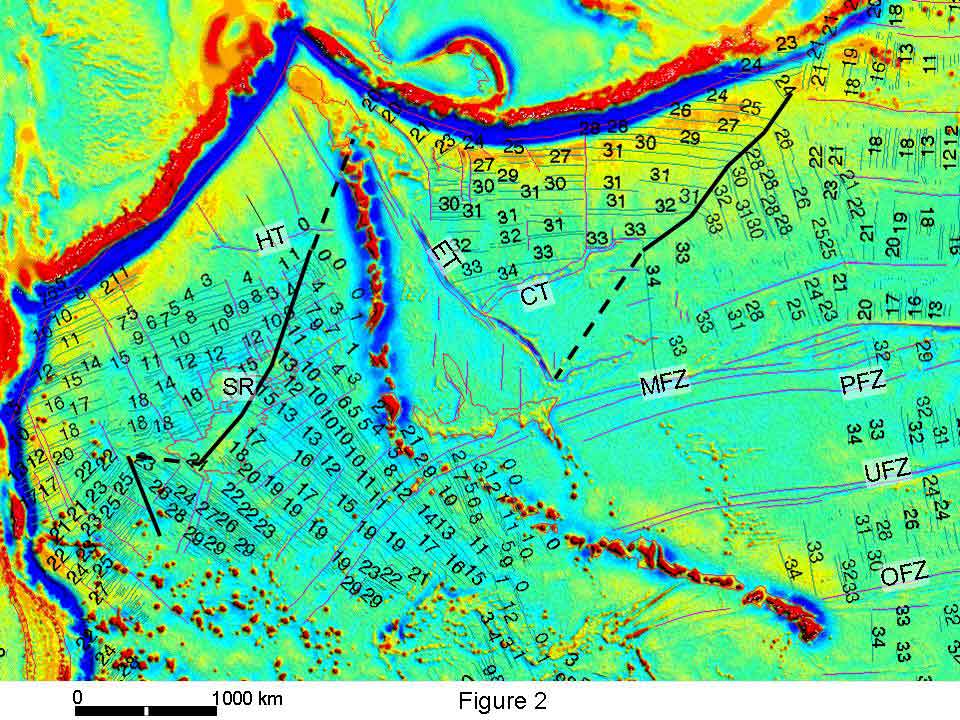
1, with named features identified. In Figure 2 the
magnetic lineations are identified, with a more subdued
gravity background. The thick black lines in Figure
2 are tracks of triple junctions where they can be
mapped from magnetic lineations; lines are dashed
where tracks are inferred within the Cretaceous normal
polarity interval.
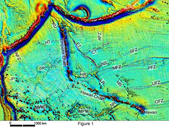
Figure 1. Free air
gravity map of the northern Pacific (Sandwell
13.1, 2005). Thin magenta lines are mapped fracture
zones, thin yellow lines are identified magnetic lineations.
SR = Shatsky Ridge; HR = Hess Rise; ET = Emperor Trough;
CT = Chinook Trough; SFZ = Surveyor Fracture Zone;
MFZ = Mendocino Fracture Zone; PFZ = Pioneer Fracture
Zone; UFZ = Murray Fracture Zone; OFZ = Molokai Fracture
Zone; AFZ = Amlia Fracture Zone; LR = Liliuokalani
Ridge; MS = Musicians Seamounts; JP = Japanese Group
seamounts; MWC = Marcus Wake chain; MPM = Mid Pacific
Mountains; NFZ = Nosappu fracture zone; NR = Necker
Ridge; KU = Kruzenstern fracture zone; NS = Non Surveyor
feature, HT = Hokkaido Trough. Magnetic lineations
(identified in Figure 2) are from compilatioms maintained
by Larry Lawver and Lisa Gahagan at the Plates Project,
Univerity of Texas at Austin, and my own updates digitized
from Nakashini et al. (1989) and Atwater (1989). Mercator
projection; scale bar is for approximately the latitude
of Hess Rise. Click here
or on Figure for enlargement.

Figure 2. Identified
magnetic lineations in the North Pacific. Heavy black
lines track triple junctions, dashed where inferred.
M-sequence lineations are west of the Hawaii-Emperor
chain; they are numbered without the M prefix. Click
here or
on Figure for enlargement.
Previous interpretations of the
North Pacific include those of Larson & Chase
(1972), Hilde et al. (1976, 1977), Woods
& Davies (1982), Rea & Dixon
(1983), Mammerickx & Sharman (1988),
Atwater (1989) and Smith (2003).
As discussed in Norton (2006), differences
between these interpretations lie mostly in how tectonic
evolution during the Cretaceous quiet zone is interpreted.
One important difference lies in what plate(s) moved
generally northward away from the Pacific. Larson
& Chase (1972) and Hilde et al.
(1976, 1977) assume that this plate was always the
Kula plate. Woods & Davies (1982) suggested
that the Kula plate only came into existence at Chron
34 time (84 Ma) and that the plate along the northern
boundary of the Pacific plate during M-sequence time
was another plate, the Izanagi. I suggest, however,
that the earlier interpretations are correct and that
there was always only one plate bordering the northern
Pacific plate. For convenience I follow the convention
developed over the past 24 years and refer to the
Izanagi as the older plate and Kula as the younger,
but finally use the name Kula/Izanagi for the single
plate.
Tectonic evolution is presented
here as a series of figures showing progressive changes
in the Pacific, Izanagi, Kula and Farallon plate boundaries,
using the time scale of Gradstein et al.
(2004). I use the gravity and tectonic data map, Figure
2, as a base. Figures step though time showing areas
of sea floor appearing as they are created. Figure
3 is a copy of Figure 2 with the area north and west
of the trench blanked out. This is done to emphasize
that the sea floor we are dealing with was a long
way from any continental margin when it formed, as
shown in Figure 4. This is a Pacific-wide reconstruction
for 80 Ma, using the plate circuit approach for calculating
relative plate positions (rotation poles from Norton,
1995). It is not possible to calculate the position
of the Pacific plate relative to the continents during
M-sequence time, as the Pacific was totally surrounded
by subduction zones and the fixed hotspot reference
frame can no longer be regarded as valid (Tarduno
et al., 2003). The plate circuit can only be
used for times later than 90 Ma, when the Pacific
became attached to New Zealand and rifted from West
Antarctica.
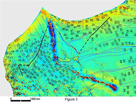
Figure 3. Same as
Figure 2 but with area north and west of the subduction
zone blanked out. This is done to emphasize that the
area of the Pacific that we are dealing with was tectonically
active while it was a long way from the margin. Click
here or
on Figure for enlargement.
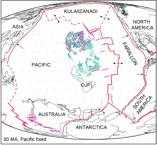
Figure 4. Plate reconstruction
for 80 Ma. Arrows indicate relative motion across
plate boundaries (red lines) which are dashed where
inferred. Green lines are magnetic lineations, magenta
lines are fracture zones. OJP = Ontong Java plateau.
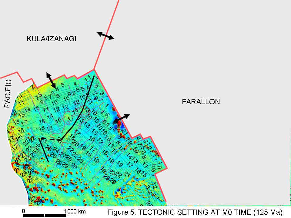
Figures 5 through 10 step through
the tectonic evolution from 125 to 71 Ma.
125
Ma (M0, Figure 5)
-
Pacific plate
boundaries are constrained by magnetic lineations.
-
Izanagi –
Farallon boundary is drawn assuming a RRR triple
junction.
-
Shatsky Rise
formed along the track of the migrating triple junction
(Sager et al., 1999).
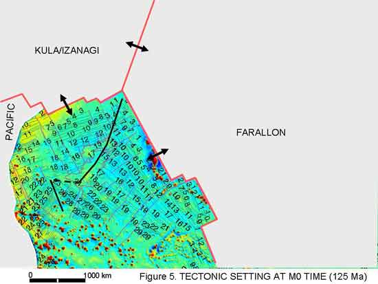
Figure 5. Tectonic
setting at M0 time, 125 Ma. Heavy red lines are plate
boundaries, arrows show relative motion directions.
Click here
or on Figure for enlargement.
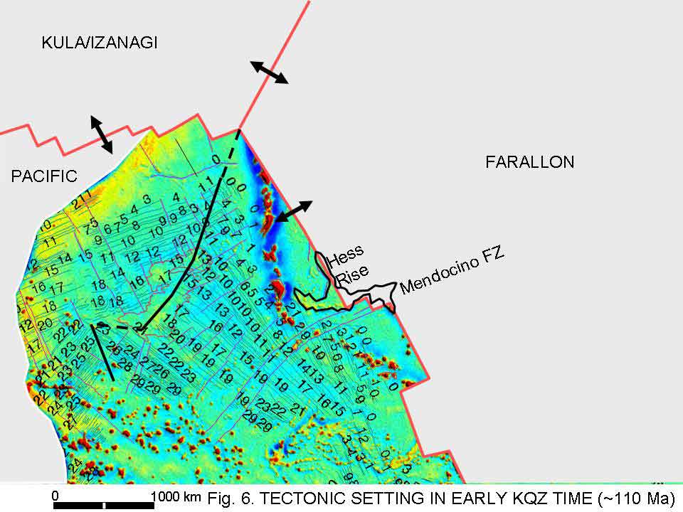
-
Pacific plate
boundaries extrapolated into the quiet zone from
the M sequence using spreading rates from Nakanishi
et al. (1989).
-
Izanagi –
Farallon boundary drawn assuming a RRR triple junction.
-
Hess Rise
straddles the presumed Pacific-Farallon spreading
axis, suggesting that the rise formed as a result
of extra volcanism at a spreading center, possibly
associated with a spreading direction change.
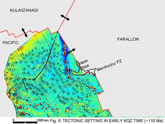
Figure 6. Tectonic
setting at approximately 110 Ma. Click here
or on Figure for enlargement.
-
Pacific plate
boundaries extrapolated into the quiet zone back
in time from Chron 34.
-
Izanagi –
Farallon boundary drawn assuming a RRR triple junction.
-
Izanagi–Pacific
spreading assumed to continue in a NW direction
as implied by the Kruzenstern and parallel fracture
zones in the far north.
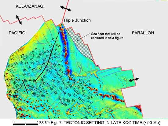
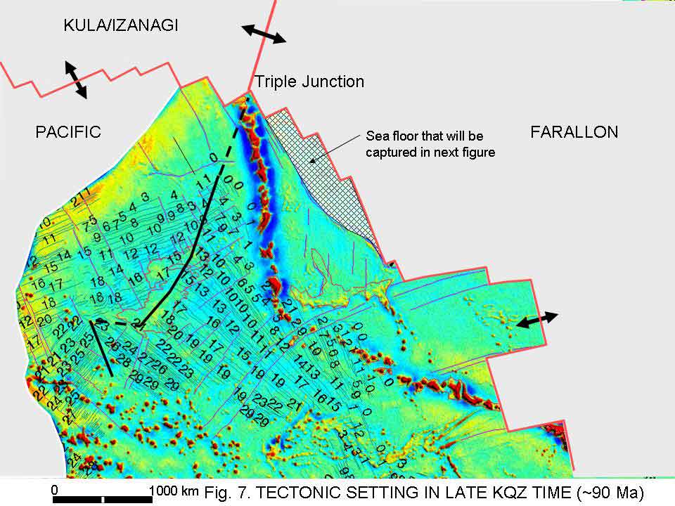
Figure 7. Tectonic
setting late in the quiet zone at 90 Ma. Click here
or on Figure for enlargement.
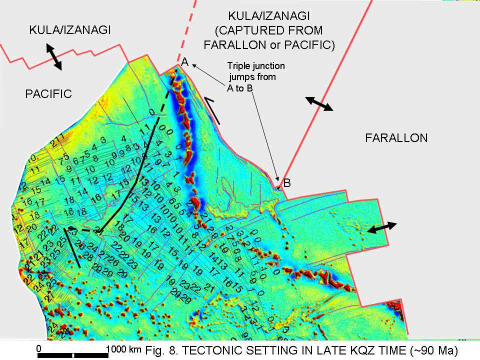
-
The time
maybe as little as 1 m.y. after Figure 7.
-
Triple junction
jumps to southeast from A to B; drawn assuming a
RRR configuration.
-
Emperor Trough
formed as a sinistral transform fault.

Figure 8. Tectonic
setting at 90 Ma after the triple junction jumped from
A to B, creating the Emperor Trough as a sinistral transform
fault. Click here
or on Figure for enlargement.
84
Ma (Chron 34, Figure 9)
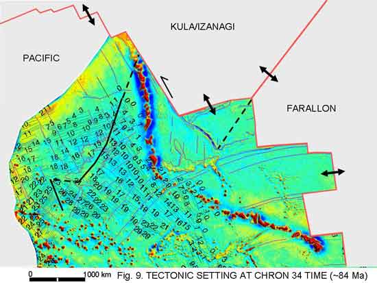
Figure 9. Tectonic
setting at Chron 34, 84 Ma. Click here
or on Figure for enlargement.
71
Ma (Chron 32, Figure 10)
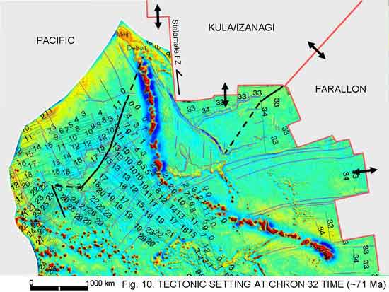
Figure 10. Tectonic
setting at Chron 32, 71 Ma. Kula spreading direction
has reoriented to north relative to the Pacific plate.
Meiji seamount, which was close to the ridge axis in
the previous figure, is now several hundred kilometers
from the ridge. Click here
or on Figure for enlargement.
Implications
for the origin of the Hawaii hotspot
As presented here, Jurassic through
end Cretaceous tectonic evolution of the North Pacific
involved just three plates. These were the Pacific,
Farallon and Kula/Izanagi plates. There is no reason
to invoke extra plates such as the Chinook (Rea
& Dixon, 1983). Changes in spreading direction
implied by changes in fracture-zone- and magnetic-lineation
strike can all be accounted for with a simple three-plate
system. Anomalous topographic features in the area
were created in several ways: Shatsky Rise by excess
ridge axis-type volcanism at a triple junction (Sager
et al., 1999; Mahoney et al., 2005);
Hess Rise by excess volcanism at a ridge-transform
intersection perhaps associated with a spreading direction
change (Figure 6); Chinook Trough by ridge reorganization
also associated with a spreading direction change
(Figure 9); Emperor Trough as a fracture zone (Figure
8) and Meiji Seamount at a spreading ridge associated
with both a spreading direction change and perhaps
at the ridge left behind by a ridge jump (Figures
9 and 10).
The three-plate tectonic model
presented above, which is similar to models proposed
by Larson & Chase (1972), Hilde et
al. (1977) and Smith (2003), leads to
a scenario for initiation of the Hawaii – Emperor
seamount chain. The oldest dated seamount in the chain,
Detroit seamount (Figure 10) is 75.8 million years
old (40Ar/39Ar from whole rock
basalt samples and feldspar separates; Tarduno
et al., 2003, Doubrovine & Tarduno,
2004; Clouard
& Bonneville,
2005), although 40Ar/39Ar
ages as old as 81.2 Ma have been obtained from basalts
cored on the seamount (Keller et al., 1995).
Meiji seamount at the northern end of the chain is
not reliably dated. Based on extrapolation from Detroit
seamount, its age is thought to be about 85 Ma (Tarduno
& Cottrell, 1997; Regelous et al.,
2003). Direct evidence yields younger ages. Dalrymple
et al. (1980) reported a minumun K-Ar age of
61.9 ± 5 Ma. Fossil assemblages in overlying
sediments suggest an age of 68-70 Ma (Worsley,
1973). I assume here that these ages are indeed minimum
ages and that Meiji is as old as 85 Ma.
Geochemical evidence presented
by Keller et al. (2000), particularly strontium,
lead and neodymium ratios, are also consistent with
formation of Meiji and Detroit seamounts close to
a ridge axis. I suggest here that Meiji formed at
the Pacific – Kula/Izanagi ridge axis as a result
of excess volcanism associated with the 30° change
in spreading direction from 84 to 71 Ma shown in Figures
9 and 10. As inferred in Figure 10, Meiji may actually
have formed at an abandoned spreading center left
behind as north-directed spreading became established.
Meiji is the oldest preserved
seamount in the Hawaii-Emperor seamount chain. Whether
there were older seamounts in the chain that have
been subducted is, of course, not known. However,
if the inference from gravity data, isotopic data
and the plate boundary scenario presented above that
Meiji formed at a ridge axis is correct, it is likely
that Meiji is the oldest seamount in the chain. If
this is so, and it formed by processes related to
sea floor spreading, an important implication is that
the Hawaii hotspot also formed by processes initiated
at the (abandoned?) spreading ridge. This means that
the hotspot formed as a result of spreading processes
and plate tectonic motion. It would, of necessity,
have a shallow (upper mantle) origin. This is different
to the usual model for a hotspot as being derived
from the mantle or core remote from the influences
of plate tectonic processes and thus superimposed
on plate processes, with little interaction between
the two. The shallow model is along the lines of the
"plate model" for the Earth proposed by
Anderson
(2005) and the "alternative Earth" of
Hamilton
(2003).
Some philosophical points regarding
plate tectonic processes that are pertinent to further
discussion are:
-
Plate motion
is primarily driven by slab pull. Spreading ridges,
once established, can provide some driving force,
but they are essentially passive features that react
to spreading-direction changes by quickly re-orienting
themselves to be orthogonal to the spreading direction.
-
Volcanism
can be generated almost anywhere. There is always
a supply of magma available for eruption, provided
a suitable channel to the surface such as a rift
is created by plate forces (Favela
& Anderson,
1999). This is why almost all oceanic spreading
ridges spread symmetrically; there is no preferred
supply direction that, if it existed, would make
ridges spread asymmetrically. An impressive example
of ongoing volcanism in an extensional environment
is the Cenozoic volcanism of western North America.
See the animations by Glazner
et al.
(2005) and Walker et al. (2004); over
4,000 radiometric ages in this compilation demonstrate
how volcanism occurs all over the area, with little
evidence for geometric patterns.
-
Volcanism
has a supply and demand balance. Most spreading
ridges move along with supply (asthenospheric melt)
matching demand (the volume of material required
by spreading). As slab pull provides most of the
plate driving force, spreading rates vary widely
but for most of the world’s ridges, supply
matches demand. Hess Rise could be an example of
a case when supply briefly exceeded demand. An example
of an extensional environment where volcanism is
lacking may be the Australia-Antarctica Discordance.
In this spreading ridge system south of Australia
there seems to be a lack of volcanism (i.e.
insufficient supply) in the spreading process (West
et al., 1997).
-
There must
be flow of asthenospheric material towards ridge
axes to provide new oceanic crust. Although most
of this flow would be perpendicular to the ridge,
i.e. bringing material in from the ridge
flanks, there could be some flow along the ridge.
This scenario was elegantly investigated for several
triple junctions by Georgen & Lin (2002).
These authors showed how triple junction geometry
and spreading rates can affect axial flow in the
vicinity of the triple junction. I suggest that
at Shatsky Rise there was a net flow towards the
triple junction that resulted in excess volcanism
that created the rise.
In our supply-demand
scenario, if demand changes (spreading slows or increases),
supply simply changes as well. I hypothesize, though,
that there can be cases where supply becomes so organized
that it continues even if the spreading ridge moves
away. This could be what happened at Meiji: the spreading
ridge moved away in response to changing spreading geometries,
but volcanism was so well-established that it continued
lava generation, forming the seamount. To form the hotspot,
i.e. a long-lived oversupply situation, requires
that a melting center be formed that remains self-sustaining.
An intriguing thought is that, if a melting center can
be initially generated as a result of spreading, i.e.
shallow, processes, it could eventually tap deeper mantle
processes (the classic plume, for instance). This could
be what happened at the bend in the Hawaii-Emperor chain
– the hotspot intersected a mantle plume and changed
character. It still remains to explain, though, what
could generate a long-lived melting anomaly (hotspot)
like Hawaii, starting with tectonically-induced excess
volcanism at Meiji seamount.
Acknowledgements
I thank Gillian Foulger for
the encouragement to write this note. It arose from
conversations with Will Sager and John Tarduno at
the AGU Chapman Conference “The
Great Plume Debate: The Origin and Impact of LIPs
and Hot Spots” and their insight is appreciated.
I also thank Brian Bell, Ian Campbell, Gillian Foulger,
Warren Hamilton, Dean Presnall, Dave Sandwell and
Tony Watts for stimulating discussions. I thank Lisa
Gahagan and Larry Lawver of the Plates Project, Univ.
Texas Institute for Geophysics, for permission to
use their magnetic lineation and fracture zone compilations.
Permission from Dave Sandwell to use his gravity data
in the figures, and Doug Robertson and Bob Brovey
for their help in generating the plots, is gratefully
acknowledged.
References
-
Anderson,
D.L., 2005: Scoring hotspots: the plume and plate
paradigms, in G.R. Foulger, J.H. Natland, D.C. Presnall
and D.L. Anderson, eds., Plates, Plumes, and
Paradigms, Geol. Soc. Amer. Spec. Paper 388,
pp. 31-54.
-
Atwater, T,
1989: Plate tectonic history of the northeast Pacific
and western North America, in E.L. Winterer, D.M.
Hussong and R.W. Decker, eds., The Geology of
North America, Vol. N, The Eastern Pacific
Ocean and Hawaii, Geol. Soc. Amer., pp. 21-70.
-
Clouard,
V. and A. Bonneville, 2005: Ages of seamounts, islands
and plateaus on the Pacific plate, in G.R. Foulger,
J.H. Natland, D.C. Presnall and D.L. Anderson, eds.,
Plates, Plumes, and Paradigms, Geol. Soc.
Amer. Spec. Paper 388, 71-90.
-
Dalrymple,
G.B., M.A. Lanphere and J.H. Natland, 1980: K-Ar
minimum age for Meiji Guyot, Emperor seamount chain,
in E.D. Jackson et al., eds., Initial reports
of the Deep Sea Drilling Project, 55, pp. 677-683.
-
Doubrovine,
P.V. and J.A. Tarduno, 2004: Late Cretaceous paleolatitude
of the Hawaiian hot spot: New paleomagnetic data
from Detroit Seamount (ODP Site 883), Geochem.
Geophys. Geosys., Q11L04, doi:10.1029/2004GC000745.
-
-
Georgen, J.E.
and J. Lin, 2002: Three-dimensional passive flow
and temperature structure beneath oceanic ridge-ridge-ridge
triple junctions, Earth Planet. Sci. Lett.,
204, 115-132.
-
Glazner,
A.F., 2005: Animations
of the NAVDAT database.
-
Gradstein,
F.M., J.G. Ogg and A.G. Smith, 2004: A Geologic
Time Scale 2004, Cambridge Univ. Press.
-
-
Hilde. T.W.C.,
N. Isezaki and J.M. Wageman, 1976: Mesozoic sea-floor
spreading in the North Pacific, Geophysical Monograph
19, The geophysics of the Pacific Ocean basin
and its margin, pp. 205-226.
-
Hilde, T.W.C.,
S. Uyeda and L. Kroenke, 1977: Evolution of the
western Pacific and its margin, Tectonophysics,
38, 145-165.
-
Keller, R.A.,
M.R. Fisk and W.M. White, 2000: Isotopic evidence
for Late Cretaceous plume-ridge interaction at the
Hawaiian hotspot, Nature, 405,
673-676.
-
Larson, R.L.
and C.G. Chase, 1972: Late Mesozoic evolution of
the western Pacific Ocean, Geol. Soc. Amer.
Bull., 83, 3627-3644.
-
Mahoney, J.J.,
R.A. Duncan, M.L.G. Tejada, W.W. Sager and T.J.
Bralower, 2005: Jurassic-Cretaceous boundary age
and mid-ocean-ridge-type mantle source for Shatsky
Rise, Geology, 33, 185-188.
-
Mammerickx
J. and G.F. Sharman, 1988: Tectonic evolution of
the North Pacific during the Cretaceous quiet period,
J. Geophys. Res., 93,
3009-3024.
-
Norton, I.O.,
1995: Plate motions in the Norh Pacific: the 43
Ma non-event. Tectonics, 14,
1080-1094.
-
Rea, D.K.
and J.M. Dixon, 1983: Late Cretaceous and Paleogene
tectonic evolution of the North Pacific Ocean, Earth
Planet. Sci. Lett., 65, 145-166.
- Norton, I.O., 2006: Speculations on
tectonic origin of the Hawaii hotspot, paper in preparation
for G.R. Foulger and D.M. Jurdy, eds., The Origins
of Melting Anomalies: Plumes, Plates, and Planetary
Processes, Geol. Soc. Am. Special paper.
-
Regelous,
M., A.W. Hofmann, W. Abouchami and S.J.G. Galer,
2003: Geochemistry of lavas from the Emperor Seamounts,
and the geochemical evolution of Hawaiin magmatism
from 85 to 42 Ma, J. Petrol., 44,
113-140.
-
Sager, W.W.,
K. Jinho, A. Klaus, M. Nakanishi and L.M. Khankishiyeva,
1999: Bathymetry of Shatsky Rise, northwest Pacific
Ocean; implications for ocean plateau development
at a triple junction, J. Geophys. Res.,
104, 7557-7576.
-
-
Smith, A.D.,
2003: A re-appraisal of stress field and convective
roll models for the origin and distribution of Cretaceous
to Recent intraplate volcanism in the Pacific basin,
Int. Geol. Rev., 45, 287-302.
-
Tarduno, J.A.
and R.D. Cottrell, 1997: Paleomagnetic evidence
for motion of the Hawaiian hotspot during formation
of the Emperor seamounts, Earth Planet. Sci.
Lett., 153, 171-180.
-
Tarduno, J.A.,
R.A. Duncan, D.W. Scholl, R.D. Cottrell, B. Steinberger,
T. Thordarson, B.C. Kerr, C.R. Neal, F.A. Frey,
M. Torii, C. Carvallo, 2003: The Emperor seamounts:
Southward motion of the Hawaiian hotspot plume in
Earth’s mantle, Science, 301,
1064-1069.
-
Walker, J.D.,
T.D. Bowers, A.F. Glazner, G.L. Farmer, and R. Carlson,
2004: Creation of a North American volcanic and
plutonic rock database (NAVDAT), Rocky Mountain
(56th Annual) and Cordilleran (100th Annual) Joint
Meeting (May 3–5, 2004) Paper No. 2-1
-
West, B.P.,
W.S.D. Wilcock, J.C. Sempéré and L.
Géli, 1997: Three-dimensional structure of
asthenospheric flow beneath the Southeast Indian
Ridge, J. Geophys. Res., 102,
7783-7802.
-
Woods, M.T.
and G.F. Davies, 1982: Late Cretaceous genesis of
the Kula plate. Earth Planet. Sci. Lett.,
58, 161-166.
-
Worsley, J.R.
1973: Calcareous nannofossils, Leg 19 of the Deep
Sea Drilling Project, Init. Reports. DSDP 19, 741-650.
|