 |
Icelandia |
Gillian R. Foulger1, Laurent Gernigon2 & Laurent Geoffroy3
1Department of Earth Sciences, Durham University, Science Laboratories, South Rd. DH1 3LE, UK; g.r.foulger@durham.ac.uk
2Norges Geologiske Undersøkelse (NGU), Geological Survey of Norway, Leiv Erikssons vei 39, N-7491 Trondheim, Norway; Laurent.Gernigon@ngu.no
3Laboratory Geosciences Ocean, UMR 6538 CNRS, IUEM, Université de Bretagne Occidentale, Place Copernic, 29280 Plouzané, France; Laurent.Geoffroy@univ-brest.fr
This webpage is a summary of: Foulger, G.R., Gernigon, L., and Geoffroy, L., 2021, Icelandia, in Foulger, G.R., Hamilton, L.C., Jurdy, D.M., Stein, C.A., Howard, K.A., and Stein, S., eds., In the Footsteps of Warren B. Hamilton: New Ideas in Earth Science: Geological Society of America Special Paper 553, p. 1–12, https://doi.org/10.1130/2021.2553(04)
Introduction
We propose a new, sunken continent beneath the North Atlantic Ocean that we name Icelandia. The region we identify includes most or all of the Greenland-Iceland-Faroe Ridge and the Jan Mayen Microplate Complex and covers an area of ~600,000 km2 (Figures 1 and 2). It is contiguous with the Faroe Plateau, which is known to comprise a continental block overlain by lavas and this, in turn, is contiguous with known submarine continental regions offshore Britain. If these are included in a “Greater Icelandia” the entire area is ~1,000,000 km2 in size.
We propose that Icelandia is extensively underlain by continental lithosphere in a variety of forms that may include blocks of full-thickness crust and mantle lithosphere and extended, magma-inflated continental crust forming hybrid continental-oceanic crust. Such crust is often termed "transitional" in the context of passive margins. The continental material may be continuous or show boudinage in character. The percentage of continental and magmatic material may vary during drastic thinning and lateral exhumation of the continental lithosphere.
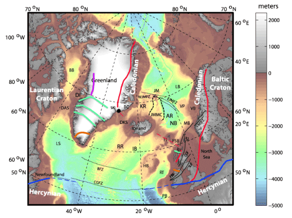
Figure 1: Regional map of the Northeast Atlantic Realm. Bathymetry is shown in color and topography in land areas in gray. DAS: Davis Strait, CGFZ: Charlie-Gibbs Fracture Zone, RR: Reykjanes Ridge, KR: Kolbeinsey Ridge, JMMC: Jan Mayen Microcontinent Complex, AR: Aegir Ridge, FI: Faroe Islands, Red lines: boundaries of the Caledonian orogen and associated thrusts, blue lines: northern boundary of the Hercynian orogen, both dashed where extrapolated into the younger Atlantic Ocean. Green lines: Nagssugtoqidian orogenic belt, magenta line: Rinkian orogeny, orange line: Ketilidian orogeny [from Foulger et al., 2020].
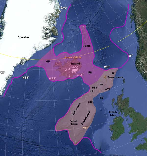
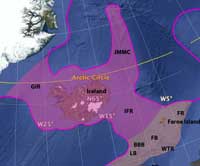
Figure 2: Bathymetric map of the NE Atlantic Ocean. Magenta line—boundary of continental crust; magenta—Icelandia; magenta + beige—Greater Icelandia; GIR—Greenland-Iceland Ridge; IFR—Iceland-Faroe Ridge; JMMC—Jan Mayen microplate complex; WTR—Wyville-Thompson Ridge; FR—Fugløy Ridge; GBB— George Bligh Bank; LB—Lousy Bank; BBB— Bill Bailey’s Bank; FB—Faroe Bank; RB—Rosemary Bank. Base map: Google Earth [from Foulger et al., 2021].
Mechanism of formation
After continental breakup caused the Northeast Atlantic Ocean to begin forming, normal seafloor spreading developed to the north and south of Iceland [e.g., Gaina et al., 2009; Gernigon et al., 2020]. However, in a ~ 300-km-wide band between ~63.5°N and 66.5°N–the future latitude band of Iceland, a strong, geological structure–the frontal thrust of the Caledonian suture–stretched from Greenland to Britain, across the line of breakup. The new spreading plate boundary could not split this barrier, or lithospheric buffer. As a result, while classical seafloor spreading and new oceanic lithosphere developed to the north and south, the barrier extended diffusely. It stretched via multiple, ephemeral spreading zones with relatively short lifetimes that continuously migrated laterally and propagated longitudinally (Figure 3).
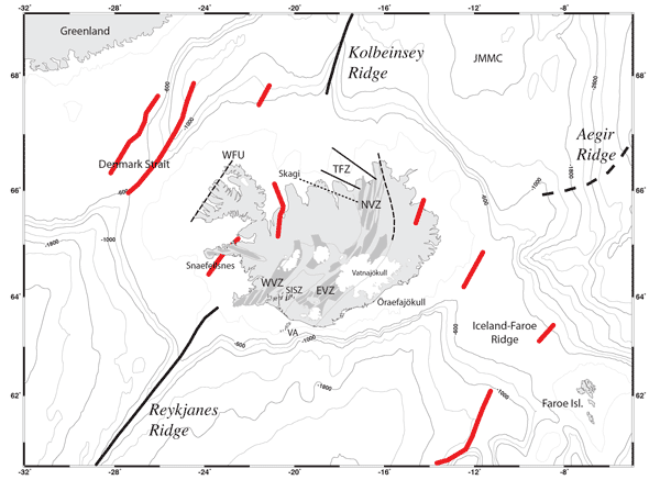
Figure 3: The Greenland-Iceland-Faroe Ridge (GIFR) and surrounding areas showing bathymetry and tectonic features. JMMC: Jan Mayen Microcontinent Complex. Thick black lines: axes of Reykjanes and Kolbeinsey Ridges, thin gray lines on land: outlines of neovolcanic zones, dark gray: currently active extensional volcanic systems, dashed black lines: extinct rifts on land, thin black lines: individual faults of the South Iceland Seismic Zone (SISZ), white: glaciers. WVZ, EVZ, NVZ: Western, Eastern, Northern Volcanic Zones, TFZ: Tjörnes Fracture Zone comprising two main shear zones and one (dotted) known only from earthquake epicenters. Thick red lines: extinct rift zones from Hjartarson et al. [2017].
A block of continental crust, probably broken off East Greenland, was trapped in this diffuse extensional zone and transported into the developing ocean [Geoffroy et al. 2015; Geoffroy et al., 2020]. It is probably a southerly extension of the Jan Mayen Microcontinent Complex (Figures 1, 2 & 3). On either side of this block, to the east and west of present-day Iceland, conjugate pairs of volcanic margins developed. These margins have similar structures to the current Vøring Plateau off the Norwegian coast, with seaward-dipping lava flows overlying stretched, magma-inflated continental crust flowing towards the central block (Figure 4) (Yuan et al., 2020).
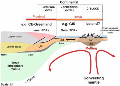
Figure 4: Volcanic passive margin (Geoffroy et al., 2020). A necking zone is associated with thick Inner-Seaward-Dipping Reflectors (SDRs) and a steeply dipping Moho. The distal ‘continental spreading zone’ has gentler Moho dips and Outer-SDRs (or flat-lying lava flows) on top of an exhumed and magma-injected high-velocity middle/lower crust. In C, LC1 and LC2 (Lower-Crust-1 and Lower-Crust-2) refer to distinct seismic characteristics within the volcanic passive margin high-velocity lower crust.
For the first ~40 Myr of opening, the entire zone from Greenland to the Faroe Islands was subaerial and formed a landbridge spanning the so-called ocean. The parts of this ancient landbridge to the west and east of Iceland subsequently subsided below sea level, but passive-margin-style volcanism continues in Iceland to the present day. There, multiple, volcanic zones are still active simultaneously along with widespread volcanism further afield. This widely dispersed volcanism testifies that the Greenland-Iceland-Faroe continental bridge still has not fully broken up and given way to classical, mono-axial seafloor spreading.
Our developing understanding of Iceland
Interpretations of the geological structure of Iceland and surrounding regions have, for many years, been dominated by the assumption that Iceland was built by essentially the same processes as occur at normal spreading plate boundaries. In this view, the crust is oceanic, and entirely constructed of basaltic volcanic rocks. Its extraordinary thickness, ~6 x that of normal oceanic crust, has been traditionally explained by unusually high temperatures.
Our new study was motivated by the inability of this model to explain several fundamental features of Iceland the surrounding shallow sea floor, and numerous other regional factors. The greatest difficulties were:
- In order to explain a crust >40 km thick purely as melt extraordinarily high temperatures would be required in the mantle beneath Iceland for which there is no clear evidence;
- Seismic measurements show that, notwithstanding the abundance of high-temperature geothermal features at the surface, the deeper crust is relatively cold, sub-solidus, and generally devoid of melt [Menke & Levin, 1994; Menke et al., 1995];
- The density of the lower part of the crust is anomalously high, while the seismic velocities are relatively normal for oceanic crust [Menke, 1999; Gudmundsson, 2003];
- The lithosphere under eastern Iceland is ~100 km thick [Bjarnason & Schmeling, 2009]–much thicker than the ~40 km expected for oceanic crust of the same age;
- How to explain the Jan Mayen Microcontinent initiation and development if the Aegir Ridge northeast of Iceland and the Reykjanes Ridge south of Iceland did not overlap.
These problems, and many others, vanish if a large part of the crust and lithosphere on Icelandia is dominantly continental. Much less melt is then required, dispensing with the need for high temperatures. A relatively low, sub-solidus temperature and the absence of melt in the deeper crust is expected if much of it is old continental crust. There is no difficulty at finding continental, lower-crustal petrologies that match the density and seismic velocity. As regards the great lithosphere thickness observed, only continental lithosphere can provide an explanation.
Testing Icelandia
The existence of Icelandia needs to be tested. There are four ways in which this could be approached:
- Magnetotelluric surveying in Iceland, possibly supplemented by offshore measurements [Björnsson et al., 2005]. Iceland has already been surveyed extensively using seismic, gravity and magnetic methods, in addition to petrology and geochemistry. However, these data are ambiguous and cannot resolve the current impasse regarding the nature of the Icelandic crust. The addition of a new, independent constraint may help to narrow candidate models;
- Ultralong, full-crust–penetrating reflection profiling along the length of the Greenland-Iceland-Faroe Ridge. This technique has been extensively applied elsewhere, e.g., in the South Atlantic and the Arctic Ocean [Nikishin et al., 2021a;b;c]. It is currently the only surveying technique that can provide a detailed picture of the structure of thick crust in the oceans;
- Dating zircon crystals collected in Iceland. Archean and Jurassic zircons have already been reported [Schaltegger et al., 2002; Paquette et al., 2006; Torsvik et al., 2015], a clear indicator of continental crust. Such observations have been pivotal in proposing continental crust elsewhere, e.g., beneath the island of Mauritius in the Indian Ocean. Nevertheless, in Iceland the measuring and reporting of zircon ages is currently incomplete.
- Deep drilling. Drilling in Iceland has not yet extended deeper than 4,659 m in well IDDP-2 at Reykjanes, at the extreme SW tip of Iceland. This is insufficient to penetrate the continental crust we propose, which may lie at depths of over 5-7 km. Drilling deeper than has currently be done, at a suitable site, is needed.
It is furthermore timely to reappraise the geology of Iceland. The questions needing to be answered are a) where does older crust underlie surface lavas [Foulger, 2006], and b) can the geology of Iceland be interpreted as an assemblage of seaward-dipping reflector–draped blocks of magma-inflated continental crust?
Implications
The theory that extensive continental crust underlies the North Atlantic Ocean raises several important issues:
- If the entire Greenland-Iceland-Faroe Ridge is extensively underlain by continental crust, full continental breakup has not yet occurred between Eurasia and Greenland, at this latitude. The feasibility of this has been demonstrated using numerical modelling [e.g., Petersen et al., 2018]);
- Is continental crust more common in other parts of the oceans than hitherto thought? Such reports are proliferating and include the recent proposals of extensive continental material beneath the oceans around New Zealand ["Zealandia"; Mortimer et al., 2017], in the Indian Ocean ["Mauritia"; Torsvik et al., 2013] and the Arctic Ocean [Nikishin et al., 2021a;b;c];
- This work in general has legal and political ramifications. The United Nations Convention on the Law of the Sea considers that submerged extensions of continental landmasses can, under some circumstances, support claims to mineral rights. Because of this, nations are investing heavily to map their offshore regions.
References
- Bjarnason, I. T., and H. Schmeling (2009), The lithosphere and asthenosphere of the Iceland hotspot from surface waves, Geophys. J. Int., 178, 394-418.
- Björnsson, A., H. Eysteinsson, and M. Beblo (2005), Crustal formation and magma genesis beneath Iceland: magnetotelluric constraints, in Plates, Plumes, and Paradigms, edited by G. R. Foulger, J.H. Natland, D.C. Presnall and D.L. Anderson, pp. 665-686, Geological Society of America.
- Foulger, G.R. (2006), Older crust underlies Iceland. Geophys. J. Int., 165: 672-676.
- Foulger, G.R., Doré, T., Emeleus, C.H., Franke, D., Geoffroy, L., Gernigon, L., Hey, R., Holdsworth, R.E., Hole, M., Höskuldsson, Á., Julian, B., Kusznir, N., Martinez, F., McCaffrey, K.J.W., Natland, J.H., Peace, A.L., Petersen, K., Schiffer, C., Stephenson, R. and Stoker, M. (2020), The Iceland Microcontinent and a continental Greenland-Iceland-Faroe Ridge. Earth-Science Reviews, 206: 102926.
- Foulger, G.R., Gernigon, L., and Geoffroy, L. (2021), Icelandia, in Foulger, G.R., Hamilton, L.C., Jurdy, D.M., Stein, C.A., Howard, K.A., and Stein, S., eds., In the Footsteps of Warren B. Hamilton: New Ideas in Earth Science: Geol. Soc. Am. Special Paper 553, p. 1–12, https://doi.org/10.1130/2021.2553(04)
- Gaina, C., Gernigon, L. and Ball, P. (2009), Palaeocene–Recent plate boundaries in the NE Atlantic and the formation of the Jan Mayen microcontinent. Journal of the Geological Society 166, 601-616.
- Geoffroy, L., Burov, E.B. and Werner, P. (2015), Volcanic passive margins: another way to break up continents. Scientific Reports, 5: 14828.
- Geoffroy, L., Guan, H., Gernigon, L., Foulger, G.R. and Werner, P. (2020), The extent of continental material in oceans: C-Blocks and the Laxmi Basin example. Geophys. J. Int., 222(3): 1471-1479.
- Gernigon, L., Franke, D., Geoffroy, L., Schiffer, C., Foulger, G.R. and Stoker, M. (2020), Crustal fragmentation, magmatism, and the diachronous opening of the Norwegian-Greenland Sea. Earth-Science Reviews, 206: 102839.
- Gudmundsson, O. (2003), The dense root of the Iceland crust, Earth planet. Sci. Lett., 206, 427-440.
- Hjartarson, A., Erlendsson, O. and Blischke, A. (2017), The Greenland–Iceland–Faroe Ridge Complex. In: G. Peron-Pinvidic, J.R. Hopper, M.S. Stoker, C. Gaina, J.C. Doornenbal, T. Funck and U.E. Arting (Editors), The NE Atlantic Region: A Reappraisal of Crustal Structure, Tectonostratigraphy and Magmatic Evolution. Geological Society, London, Special Publications, pp. 127-148.
- Menke, W. (1999), Crustal isostasy indicates anomalous densities beneath Iceland, Geophys. Res. Lett., 26, 1215-1218.
- Menke, W., and V. Levin (1994), Cold crust in a hot spot, Geophys. Res. Lett., 21, 1967-1970.
- Menke, W., V. Levin, and R. Sethi (1995), Seismic attenuation in the crust at the mid-Atlantic plate boundary in south-west Iceland, Geophys. J. Int., 122, 175-182.
- Mortimer, N., H. J. Campbell, A. J. Tulloch, P. R. King, V. Stagpoole, R. A. Wood, M. S. Rattenbury, R. Sutherland, C. J. Adams, J. Collot, and M. Seton (2017), Zealandia: Earth’s Hidden Continent, GSA Today, 27, 27–35.
- Nikishin, A. M., E. I. Petrov, S. Cloetingh, A. V. Korniychuk, A. F. Morozov, O. V. Petrov, V. A. Poselov, A. V. Beziazykov, S. G. Skolotnev, N. A. Malyshev, V. E. Verzhbitsky, H. W. Posamentier, S. I. Freiman, E. A. Rodina, K. F. Startseva, and N. N. Zhukov (2021a), Arctic Ocean Mega Project: Paper 1 - Data collection, Earth-Science Reviews, 217, 103559.
- Nikishin, A. M., E. I. Petrov, S. Cloetingh, N. A. Malyshev, A. F. Morozov, H. W. Posamentier, V. E. Verzhbitsky, S. I. Freiman, E. A. Rodina, K. F. Startseva, and N. N. Zhukov (2021b), Arctic Ocean mega project: Paper 2 – Arctic stratigraphy and regional tectonic structure, Earth-Science Reviews, 217, 103581.
- Nikishin, A. M., E. I. Petrov, S. Cloetingh, S. I. Freiman, N. A. Malyshev, A. F. Morozov, H. W. Posamentier, V. E. Verzhbitsky, N. N. Zhukov, and K. Startseva (2021c), Arctic Ocean Mega Project: Paper 3 - Mesozoic to Cenozoic geological evolution, Earth-Science Reviews, 217, 103034.
- Paquette, J., O. Sigmarsson, and M. Tiepolo (2006), Continental basement under Iceland revealed by old zircons, paper presented at American Geophysical Union, Fall Meeting.
- Petersen, K. D., C. Schiffer, and T. Nagel (2018), LIP formation and protracted lower mantle upwelling induced by rifting and delamination, Scientific Reports, 8, 16578.
- Schaltegger, U., H. E. F. Amundsen, B. Jamtveit, M. Frank, W. L. Griffin, K. Gronvold, R. G. Tronnes, and T. Torsvik (2002), Contamination of OIB by underlying ancient continental lithosphere: U-Pb and Hf isotopes in zircons question EM1 and EM2 mantle components, Geochim. Cosmochim. Acta, 66, A673.
- Torsvik, T. H., H. Amundsen, E. H. Hartz, F. Corfu, N. Kusznir, C. Gaina, P. V. Doubrovine, B. Steinberger, L. D. Ashwal, and B. Jamtveit (2013), A Precambrian microcontinent in the Indian Ocean, Nature Geoscience, 6, 223-227.
- Torsvik, T. H., H. E. F. Amundsen, R. G. Trønnes, P. V. Doubrovin, C. Gaina, N. J. Kusznir, B. Steinberger, F. Corfu, L. D. Ashwal, W. L. Griffin, S.C. Werner, and B. Jamtveit (2015), Continental crust beneath southeast Iceland, Proc. Nat. Acad. Sci., Published online March 30, 2015.
- Yuan, X., Korenaga, J., Holbrook, W. S., & Kelemen, P. B. (2020), Crustal Structure of the Greenland-Iceland Ridge from Joint Refraction and Reflection Seismic Tomography. Journal of Geophysical Research: Solid Earth, 125(7), e2020JB019847.
last updated 28th June, 2021 |